Файл:Antarctica Without Ice Sheet.png
Содержимое страницы недоступно на других языках.
Википедиядихъай

Двулдин файл(782 × 1000 пикселар, файлдин кьадар: 675 Кб, MIME жуьре: image/png)

И файл на Викискладе-кай я ва ам маса проектра кардик кутаз жеда. Адан тегьерар кхьинин ччина авай малумат агъуз къалурнава.

Нетижа

Тегьерар кхьин
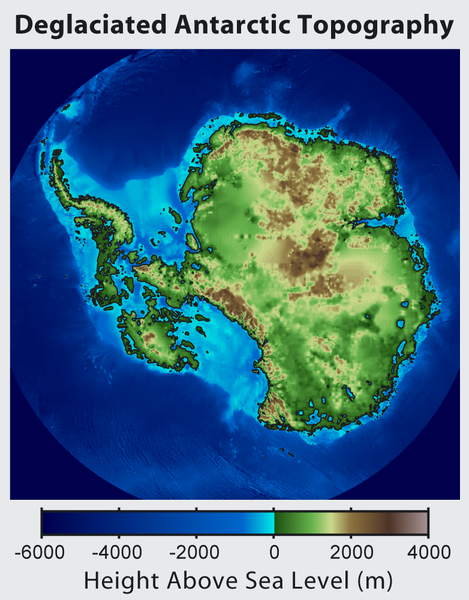
Русский: Рельеф Антарктиды с учетом поднятия земной коры после таяния ледников и повышения уровня океана
English: This is topographic map of Antarctica after removing the ice sheet and accounting for both isostatic rebound and sea level rise. Hence this map suggests what Antarctica may have looked like 35 million years ago, when the Earth was warm enough to prevent the formation of large-scale ice sheets in Antarctica.

Isostatic rebound is the result of the weight of the ice sheet depressing the land under it. After the ice is removed, the land will rise over a period of thousands of years by an amount approximately 1/3 as high as the ice sheet that was removed (because rock is 3 times as dense as ice). Approximately half the uplift occurs during the first two thousand years. If the ice sheet is removed over more than a few thousand years, then it is possible that a majority of the uplift will occur before the ice sheet fully disappears.

As indicated in the map, Antarctica consists of a large continental region (East Antarctica) and group of seas and smaller land regions (West Antarctica). Since the West Antarctic ice sheet is partially anchored below sea level, this region is less stable and more likely to be affected by global warming. Even so, it is likely that during the next century increased precipitation over Antarctica will offset melting.

Even in the event of severe sustained warming, it would take many thousands of years for Eastern Antarctica to be fully deglaciated.
Français : Carte topographique de l'Antarctique après avoir retirer la couche de glace et pris en compte le rebond isostatique ainsi que la montée du niveau de la mer Par conséquent cette carte montre ce à quoi l'Antarctique aurait pu ressembler il y a 35 millions d'années, quand la Terre était suffisament chause pour prévenir la formation d'une importante calotte glaciaire en Antarctique.

Le rebond isostatique est la conséquence de la couche de glace qui fait pression sur le sol et crée des dépressions. Après le retrait de la glace, le sol s'élève sur une période de milliers d'années par un rythme correspondant à un tiers de la hauteur de la couche de glace qui fut retirée (car la roche est trois fois plus dense que la glace). La moitié de l'élévation se fait pendant les deux premiers milliers d'années. Si la glace se retire sur une période dépassant plusieurs milliers d'année, il est possible que le rebond ait lieu avant que la couche de glace ne disparaisse complètement.

Comme montré sur la carte, l'Antarctique est composé d'une large région continentale (Antarctique oriental) et d'un groupe de mers et de petites régions terrestres (Antarctique occidental). Puisque la plaque glaciaire de l'Arctique occidental est en partie en dessous du niveau de la mer, cette région est moins stable et plus susceptible d'être affectée par le réchauffement climatique. En dépit de cela, des précipitation en Antarctique peuvent compenser la fonte. La fonte de l'Antarctique oriental prendra plusieurs milliers d'années, même en cas de réchauffement sévère et continu.
Тарих
Чешме http://www.globalwarmingart.com/wiki/File:Antarctica_Without_Ice_Sheet_png
Автор Image created by Robert A. Rohde / Global Warming Art
Другие версии File:Deglaciated Antarctic Topography.png – with no description (internationalized)

Лицензиярун

Robert A. Rohde, владелец авторских прав на это произведение, добровольно публикует его на условиях следующих лицензий:
GNU head Разрешается копировать, распространять и/или изменять этот документ в соответствии с условиями GNU Free Documentation License версии 1.2 или более поздней, опубликованной Фондом свободного программного обеспечения, без неизменяемых разделов, без текстов, помещаемых на первой и последней обложке. Копия лицензии включена в раздел, озаглавленный GNU Free Documentation License.
w:ru:Creative Commons
атрибуция гьа са шартӀаралди чукӀурун
Этот файл доступен по лицензии Creative Commons Attribution-Share Alike 3.0 Unported.
Атрибуция: Robert A. Rohde
Вы можете свободно:
  • ахъаюн – и эсер копия авун, чукӀурун ва ахъаюн
  • создавать производные – и эсер масакӀа кхьин
При соблюдении следующих условий:
  • атрибуция – Вы должны указать авторство, предоставить ссылку на лицензию и указать, внёс ли автор какие-либо изменения. Это можно сделать любым разумным способом, но не создавая впечатление, что лицензиат поддерживает вас или использование вами данного произведения.
  • гьа са шартӀаралди чукӀурун – Если вы изменяете, преобразуете или создаёте иное произведение на основе данного, то обязаны использовать лицензию исходного произведения или лицензию, совместимую с исходной.
Вы можете выбрать любую из этих лицензий.

Краткие подписи

Добавьте однострочное описание того, что собой представляет этот файл

Элементы, изображённые на этом файле

изображённый объект русский

MIME-тип русский

image/png

589d868b4476f71d9a736899eaa4a5aa88b985e9

метод определения русский: SHA-1 русский

690 846 байт

высота/рост русский

1000 пиксель

ширина русский

782 пиксель

Файлдин тарих

Файлдин виликан жуьре килигун патал, гьа а жуьредин тарих/вахт илиса,

Тарих/вахтБицlи шикилКьадарарУртахВеревирд
алай19:56, 16 июнь 201519:56, 16 июнь 2015 тарих алай жьуредин бицlи акунар782 × 1000 (675 Кб)Szczureqlarger image
08:57, 10 октябрь 201208:57, 10 октябрь 2012 тарих алай жьуредин бицlи акунар469 × 600 (316 Кб)Strannik27User created page with UploadWizard

И файл ишлемизавай чинар авай туш.

Файлдин глобал кардик кутун.

И файл агъадихъ галай викийра ишлемишзава:

Метамалуматар